
Navigating the Waters: Modelling Floods Along Vietnam's Mekong River
By Xiaoli Su

Man wading through Mekong (Constant Loubier)
The Vietnamese Mekong Delta (VMD) is a region of incredible ecological importance. It not only supports Vietnam's food security but also plays a pivotal role in socio-economic development. However, this intricate hydrodynamic system is under threat due to climate change and rapid urbanisation, leading to an increasing vulnerability to flood risks. These risks emanate from various sources, including fluvial (river-related), pluvial (rainfall-related), and coastal processes.
To address these growing challenges, we need reliable modelling tools that can simulate complex flooding scenarios, help assess hazard risks, and guide policy development.
Accurate flood prediction here is not just important; it's a game-changer. It helps us create solid flood models and assess the associated risks. However, the tools we've been using, like one-dimensional (1D) and quasi two-dimensional (2D) hydrodynamic models, have their limitations.
The Limits of Current Models
Imagine you have a river, and it overflows onto the land around it during heavy rain. These 1D and 2D models work well for understanding the river itself, but they struggle when it comes to predicting what happens when the river spills over its banks onto nearby fields or floodplains.
To handle this, these models are joined with another model, a 2D inundation model, but this connection is like a one-way street. It doesn't fully account for how the river and the overflowed land interact, which makes it tough to predict floods with certainty. In other words, it's like trying to complete a puzzle with missing pieces.
The Quest for Better Flood Predictions
What if we could create a more powerful and precise model that doesn't have these limitations? That's where the High-Performance Integrated Hydrodynamic Modelling System (HiPIMS) comes into play. HiPIMS is like the latest, high-tech gadget in our flood prediction toolbox. But before we can use it effectively, we need to fine-tune it, like adjusting the settings on a new phone to get the best pictures.
Modelling the 2011 Mekong River Floods

Simulation domain
Our primary goal is to replicate a model of the high and middle flood events in 2011 along the middle and lower stretches of the Mekong River. The 2011 flood had far-reaching consequences, impacting seven provinces and resulting in substantial losses.
The simulation domain begins at the Kratie gauge in Cambodia, a location chosen to exclude tidal influences, covering 55 kilometres. To achieve our aim, we gather data from Mekong River Commission, providing measurements of water levels and discharge of four gauge stations (Can Tho, My Thuan, Chau Doc, Tan Chau). Using this data, we fine-tune our model, ensuring that it reflects the real-world conditions accurately.
The Importance of Model Calibration
Model calibration is akin to fine-tuning a musical instrument before a performance; it's essential for achieving accurate results. Without calibration, our model could produce predictions that could be far from reality. Imagine the consequences of relying on flood forecasts that inaccurately assess the risks to communities, agriculture, and infrastructure. The potential impact is immeasurable.
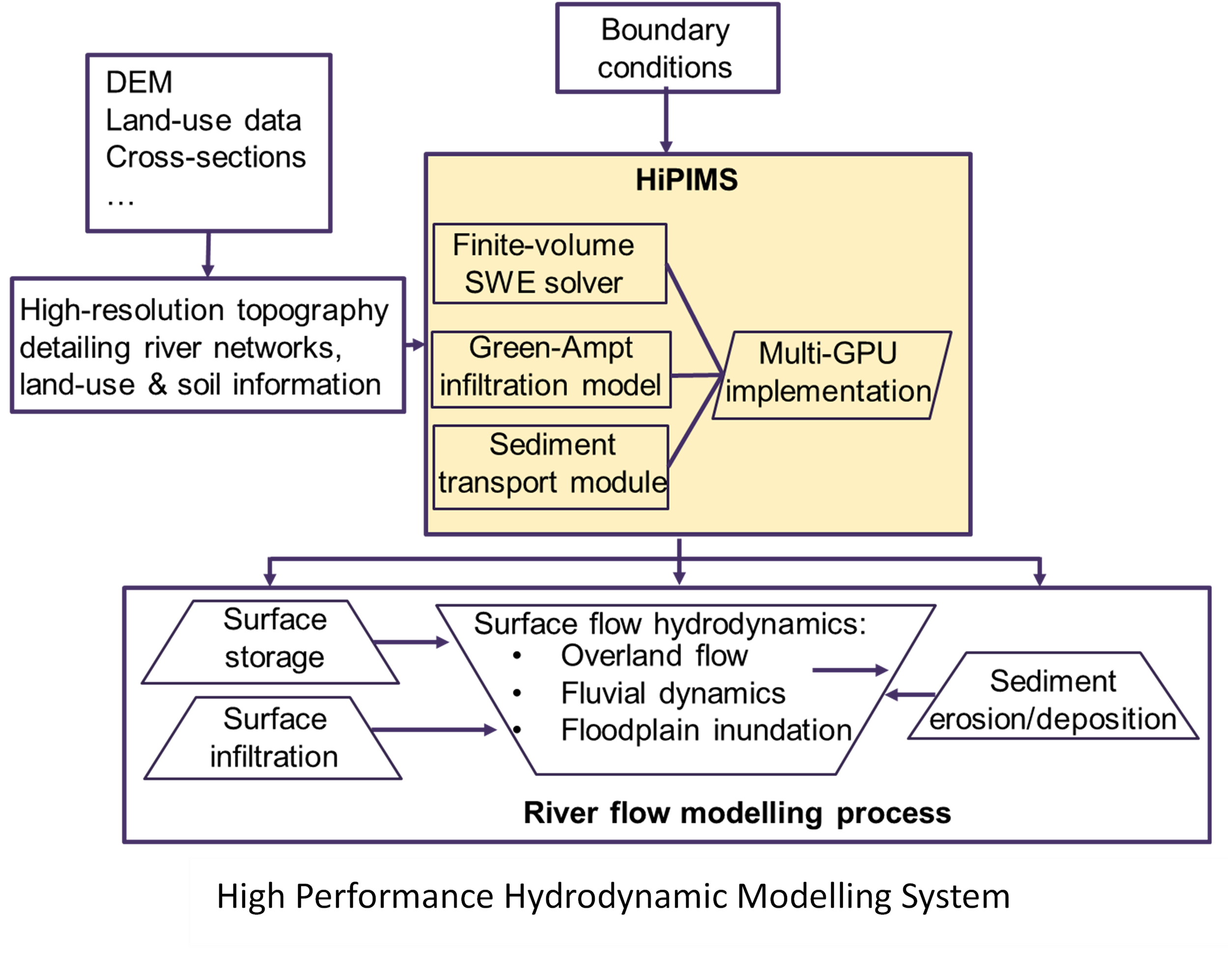
High Performance Hydrodynamic Modelling System
Why HiPIMS?
The High-Performance Integrated Hydrodynamic Modelling System (HiPIMS) holds great promise in revolutionising our approach to flood modelling. This fully 2D model enables us to simulate fluvial flooding processes comprehensively, from river channels to floodplains. Additionally, the high-performance computing capability of HiPIMS makes it possible to be applied in the large-scale simulation, like the Mekong River flow modelling.
Conclusion
In a world where climate change is intensifying the threats of flooding, our ability to accurately predict and model these events is of paramount importance. The Mekong River, a lifeline for many, faces increasing vulnerability to flood risks, needing innovative solutions. Our focus on calibrating the HiPIMS model is a step towards enhancing flood modelling capabilities, ensuring that the Mekong Delta can better prepare for and mitigate the impacts of future floods.
As we progress, we hope that our efforts will contribute to safeguarding food security, fostering socio-economic development, and ultimately, protecting the people and ecosystems that depend on this vital region.
Want to stay up to date with Xiaoli’s latest research as it progresses? Why not sign up for our newsletter?
You may also like the blog Mitigating Pluvial Flood Risks and Exploring Damage Mitigation Approaches – Case studies in Can Tho, Vietnam