Mitigating Pluvial Flood Risks and Exploring Damage Mitigation Approaches – Case studies in Can Tho, Vietnam
By Jinghua Jiang and Haoyang Qin
Can Tho, the largest city of the Mekong River Delta in Vietnam, is facing the challenges of rapid urbanisation and population growth. With the population predicted to rise to 2.5 million by 2035, the city’s flood-prone areas are also expected to increase significantly – from 30% to 50% of its total area.
Here, we present some of our explorations of flood risk and approaches to mitigate the impact of flooding in the city of Can Tho.
Why Can Tho is Vulnerable
Understanding Can Tho’s vulnerability to pluvial flooding requires us to look at two main factors. First, the city’s low-lying geography, ranging from 0.6 to 1.2 meters above sea level, severely limits its drainage capabilities. Second, climate change is exacerbating the situation, with the city witnessing rainfall events of intensities between 50-100 mm per day lasting for 30 to 120 minutes . The combination of these factors, along with an outdated drainage system, results in areas remaining submerged for hours even after the rainfall has stopped.
The Human and Financial Loss: A Deep Dive into Ninh Kieu District
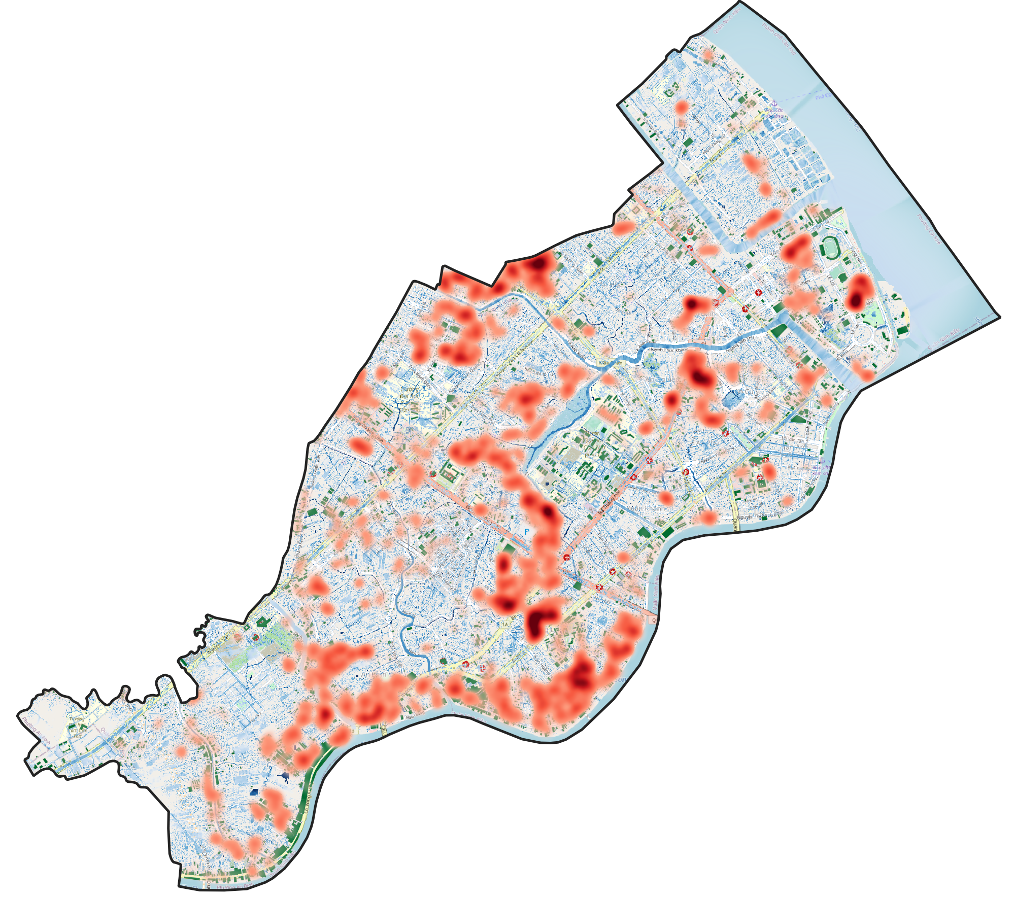
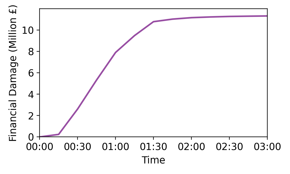
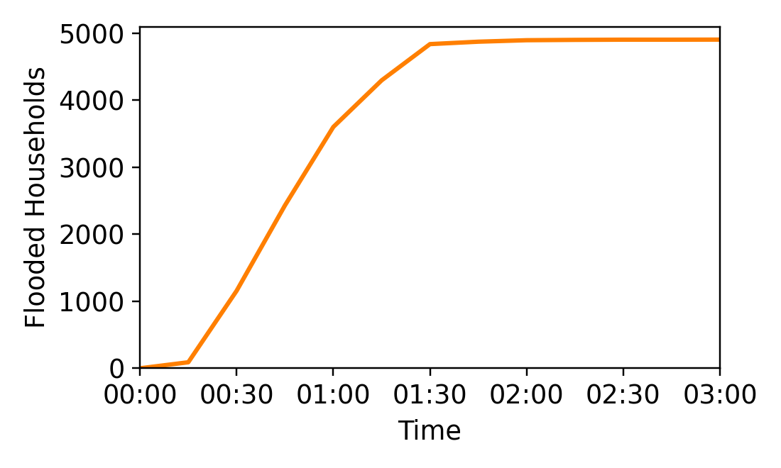
As one of Can Tho’s most developed districts, Ninh Kieu is an ideal case study to assess flood resilience. Using a Coupled Human and Natural Systems (CHANS) model, we’ve quantified the financial impact of pluvial floods on households. The model comprises two components: a High-Performance Integrated Hydrodynamic Modelling System (HiPIMS) modelling the flood processes and an Agent-Based Model (ABM) simulating the household dynamic affected by the flooding. The simulation results (Fig.1), backed by both real and simulated data, vividly depict how flood risks impact households (Fig.2) and the financial loss (Fig.3) in Ninh Kieu district.
Nature Strikes Back: Nature-Based Solutions
Fig 4: Semi-automated framework to identify the most suitable locations for Nature-based Solutions (NbS)
Nature-Based Solutions (Nbs) offer an eco-friendly approach to mitigate flooding by emulating pre-development natural drainage.
We have developed a semi-automated framework to identify the most suitable locations for Nbs based on various factors like flood risks, topography, infiltration capability and land use (Fig. 4).
Hydrodynamic modelling shows that applying different types of Nbs could significantly reduce inundation rates, even in extreme weather conditions.
Recommendations for Local Government
To further bolster the city’s resilience against flooding, we recommend that the local government invest in early warning systems to alert residents in a timely manner.
Sandbags can be used as a flood emergency response to reduce flood damage. For areas severely affected during extreme flood events from the simulation results, the government may consider distributing sandbags to help local households in emergency response. Encouraging households in these areas to prepare sandbags to improve flood resilience can also be a government strategy.
Furthermore, the application of well-planned Nbs has the potential to enhance the city’s resilience against pluvial flooding.
Looking Forward: Next Steps in Research
Our future research efforts will focus on improving the simulation model’s accuracy.
To achieve this, we are collaborating with the Living Deltas’ Household Survey team to enhance the quality of household data and financial loss estimates.
Simultaneously, we aim to explore effective ways to incorporate both stakeholders and residential communities into the Nbs implementation process, as well as to explore the efficacy of Nbs in mitigating other types of flooding, such as fluvial and compound floods.
Conclusion
As Can Tho’s population swells, integrating human behaviour into flood risk mitigation plans becomes increasingly essential. Employing innovative modelling techniques and nature-based solutions can significantly improve the city’s flood resilience, paving the way for a sustainable future.
Want to stay up to date with Jinghua and Haoyang’s latest research as it progresses? Why not sign up for our newsletter?
You may also like the blog Navigating the Waters: Modelling Floods Along Vietnam’s Mekong River


