
Cyclone Amphan in Bangladesh: An Overview
By Tasnim Kamal Shamma, Arup Talukder & Md. Robiul Hasan
Cyclone Amphan, the first tropical cyclone of 2020 in North Indian Ocean Cyclone Season is also the first super cyclonic storm to have formed in the Bay of Bengal since the 1999 Odisha cyclone. The devastating impact of Amphan mostly occurred in Eastern India, specifically West Bengal and Bangladesh. It was originated from a low-pressure area holding on 300 km east of Colombo, Sri Lanka, on 13 May, 2020 before being upgraded to a cyclonic storm and taking the name of Amphan on 16 May. The cyclone made its landfall in West Bengal on 20 May 2020 between 10:00 and 11:00 UTC, and then slammed into Bangladesh at evening with a wind speed of 150 km/h and continued its destruction among 26 districts (Satkhira, Bagerhat and Patuakhali being the most affected ones) across the country.

Figure 1: Map plotting the track of Amphan Created by Meow, using WikiProject Tropical cyclones/Tracks. The background image is from NASA. Tracking data is from NOAA
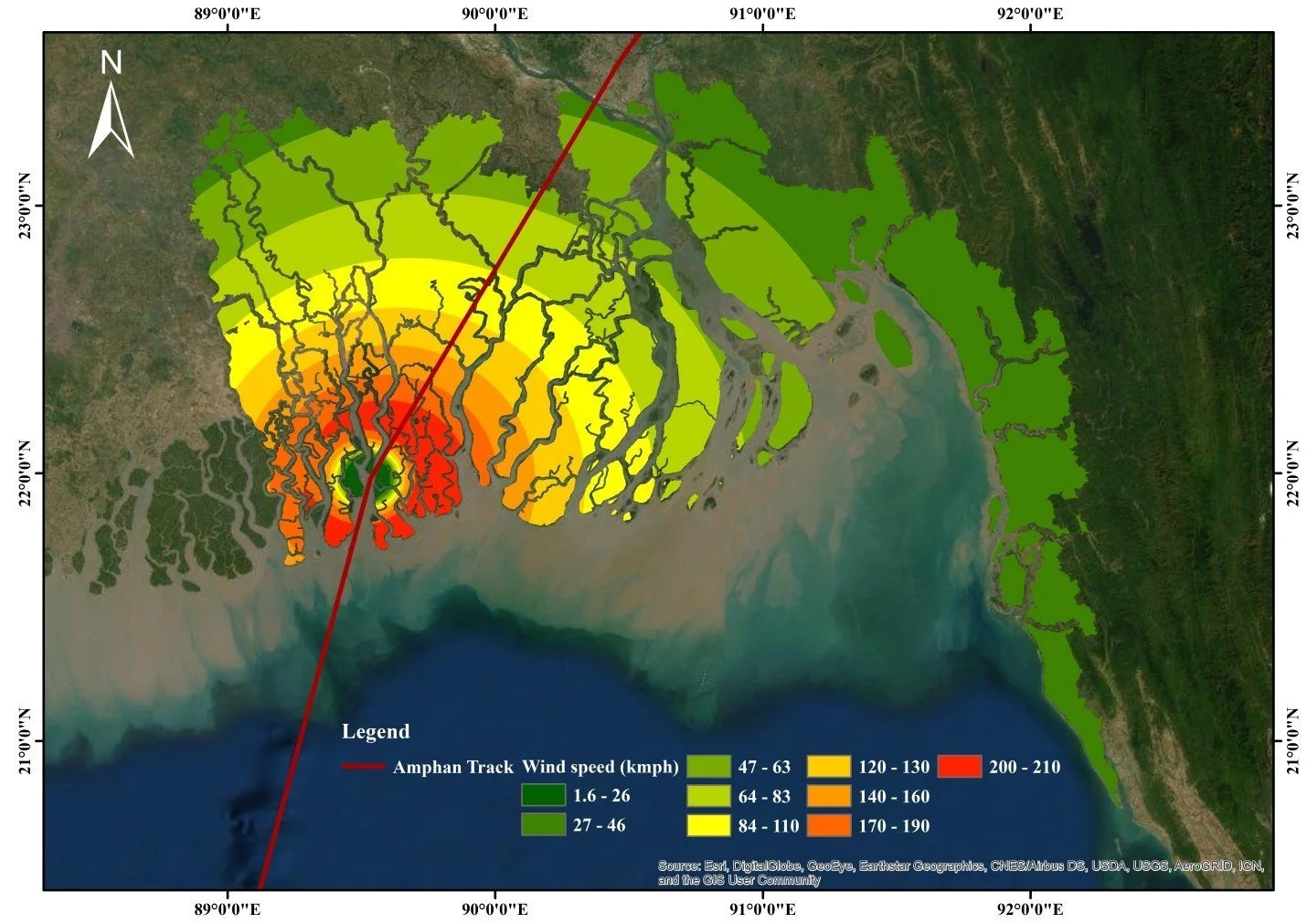
Figure 2: A simulation of wind speed of Amphan at the landfall

Figure 3: A simulation of surge height of Amphan at the landfall
Formation and Intensity of Amphan
After the formation of the low pressure area it became more marked as it gradually consolidated, further tracking north-eastward, over the next couple of days and upgraded to a tropical depression according to the Joint Typhoon Warning Center (JTWC). It gained the status of a cyclone on 16 May, when its center was approximately 600 km south-east of Visakhapatnam City (northern Andhra Pradesh, India) and 1,000 km south-west of the coastal area of Barisal Division (Bangladesh). Starting from 12:00 UTC, within just six hours, Amphan went through sharp intensification into a severe cyclonic storm on 17 May. JTWC assessed an increase in wind speed during that time from 140 km/h to 215 km/h, which was equivalent to a Category 4 hurricane on Saffir-Simpson scale. On 18th May, Amphan finally turned into Category 5 Super Cyclone reaching its peak intensity with a maximum sustained wind speed of 269-278 km/h according to JTWC. But surprisingly the cyclone started to weaken since that night, as it was encountering high VWS (Vertical Wind Shear) up to 46.3 km/h to 56.6 km/h and a deteriorating upper level environment disrupting the inner ring (eyewall) of thunderstorms. Cyclone Amphan continued to abate and weakened from a super cyclone to an "extremely severe cyclonic storm" between the 20th and the 21st May 2020, as the maximum sustained wind speed subsequently reduced to 185.2 km/h on 19 May and to 157.4 km/h at landfall on 20 May.
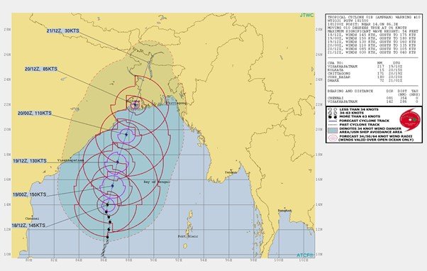
Figure 4: Amphan track on May 19 by JTWC
More than 2.4 million people were evacuated to 14,636 permanent and temporary shelters in 19 coastal districts before the impact of the cyclone at the country's coast. Officials and volunteers used loudspeakers to tell people to evacuate on 18 May while, the next day, they began going door-to-door to urge them to move to shelters. Besides, all major maritime ports of Bangladesh were asked to raise great danger signal number ten as extremely severe Cyclone Amphan approached closer to the coast.
Effect of Amphan on Bangladesh
According to BMD (Bangladesh Meteorological Department), the arms of Amphan reached the coast after 4 pm, 20th May and moved in a north-north easterly direction further and completely crossed the coast in three to four hours. Before that, BMD issued a great danger signal number 10 for 11 coastal districts of Bangladesh, including their offshore islands and chars. According to the sources, Mongla and Satkhira areas were hit with seven to eight feet high tidal waves by the cyclone’s front portion in the afternoon facing a wind speed of 115 km/h. Amphan rapidly weakened as it moved further inland and so JTWC downgraded it to a Category 1-equivalent cyclone.
Devastation in Coastal Areas
The effect on embankments and riverbanks due to Amphan was severe in some coastal districts. Reports depicts that partial damage and breach in the embankments in the Khulna region are higher than the Barishal region. Fortunately, no collapse in embankment was found in the Barishal region but it wasn’t the same for the Khulna region. On the other hand, erosion to the River bank is almost equal in length for both regions.


Figure 5 and Figure 6: Region-wise Damage of Embankment and Riverbank for Khulna and Barishal
According to preliminary reports, maximum damage to the embankment took place in Satkhira and Khulna district where embankment collapsed in 24.62 km and 29.17 km in 65 points and 28 points respectively. Breach of the Flood control infrastructure was 74 km in 77 points and 21.6 km in 132 points of Satkhira and Patuakhali district respectively.


Figure 7 and Figure 8: Points of Damage and Length of Damage in several districts
Loss Assessment
As the cyclone passed through each district, it continued its devastation throughout the route. According to the United Nations office in Bangladesh, approximately 10 million people have been affected by Amphan while the most affected districts are reported to have been Khulna, Jashore, Satkhira, Bagerhat, Pirojpur, Barguna, Patuakhali, Bhola and Noakhali. 26 people lost their lives, 205,368 houses were damaged and 55,767 houses were destroyed in the 19 affected districts, as per the analysis of the report of Need Assessment Working Group (NAWG2) on 31 May. Moreover, the report also mentioned 40,894 latrines, 18,235 water points being affected, 32,037 hectares of crops and vegetable damage, 18,707 hectors of fish cultivation area destruction, 440 km of road and 76 km of embankment damage. In total, 1,100 kilometers of roads, 200 bridges and culverts were damaged. Alongside these structural damages, 180,500 hatcheries were affected resulting in a financial loss worth Tk. 325 Million taka (USD 38.3 Million). While the southern part was devastated with economic losses in the fisheries sector, the northern part went through major economic loss due to the destruction of mango orchards. Approximately, mangoes worth 1500 Million taka (USD 17.7 Million) were damaged during Amphan as it occurred near the harvesting season. Overall, the initial Government estimates the total damage to be BDT 11 billion (USD 130 million) in housing, infrastructure, fisheries, livestock and crops.
A cyclone like Amphan on its own is devastating enough, however, the pandemic situation made the risk even higher. In terms of early actions taken by the government, accurate advance forecasts and the evacuation of hundreds of thousands of people were the primary reason for keeping the death toll to a minimum. Previously built 12,078 cyclone shelters in the coastal region, help from numerous humanitarian agencies helped keep people safe during the disaster. The structural damage was slightly minimized due to The Sundarbans on the south but excess rainfall made the flooding and inundation condition extreme in several districts leaving 154 unions inundated. Overall, this was noted as the strongest storm to strike the GBM delta since Sidr of 2007.