
Community Science
Authors: Sourav Das, Heather Moorhouse & Lucy Roberts

Sourav Das and Sumana Banerjee measuring household pond water quality in Bali Island, GBM-I.
The Community Science subgroup aims to work alongside delta communities to understand how their local surface water environments have and are changing. It is hoped activities such as photography and water quality monitoring will be fun, engaging and empowering for communities to inform on sustainable water management. For the Hub working with communities provides a deeper understanding of who accesses, depends on and experiences which waters, and so, adds a personal dimension to the delta-wide water quality monitoring programme developed by the Hub.
Recently, Sourav Das and colleagues (Sumana Banerjee, Dr. Abhra Chanda, Prof. Tuhin Ghosh) visited Bali Island in the Indian Ganges Brahmaputra Meghna delta to research pond use and water quality from 5 sites across the Island. Bali Island is one of 9 islands within the Gosaba block of the Indian Sundarbans. Forest-based livelihoods such as crab, fish and prawn collection for aquaculture and honey collection are common on the island though tourism is becoming an attractive industry here1. Freshwater sources are important resources in the Sundarbans and Bali island is subsequently surrounded by river embankments to prevent saltwater flooding during extreme events such as Cyclone Aila in 2009 and from sea level rise. Freshwater ponds are important surface waters in Asian Mega-deltas for the provision of water for drinking, sanitation, and food production. They range from smaller household domestic/sustenance ponds to large industrial aquaculture ponds and are dotted throughout the delta landscape.
To understand use and management of ponds in the area, household pond owners/user were interviewed about water quality changes over monsoonal periods and extreme events, and whether the use (type of activity and frequency) of their pond reflects these patterns. These questionnaires were developed from student-led surveys on water usage in the Mekong Delta already conducted by Hub colleagues in 2020. On Bali Island, measurements of pond water quality were undertaken alongside surveys. These measurements can account for agricultural, aquacultural or human waste (e.g. the nutrient content) and human and livestock faecal pollution (e.g. faecal coliforms). Contamination of this nature can render ponds unsafe and unusable. The information gathered on this trip will enable more pond owners to pinpoint management concerns and researchers to understand patterns of environmental change over space and time.
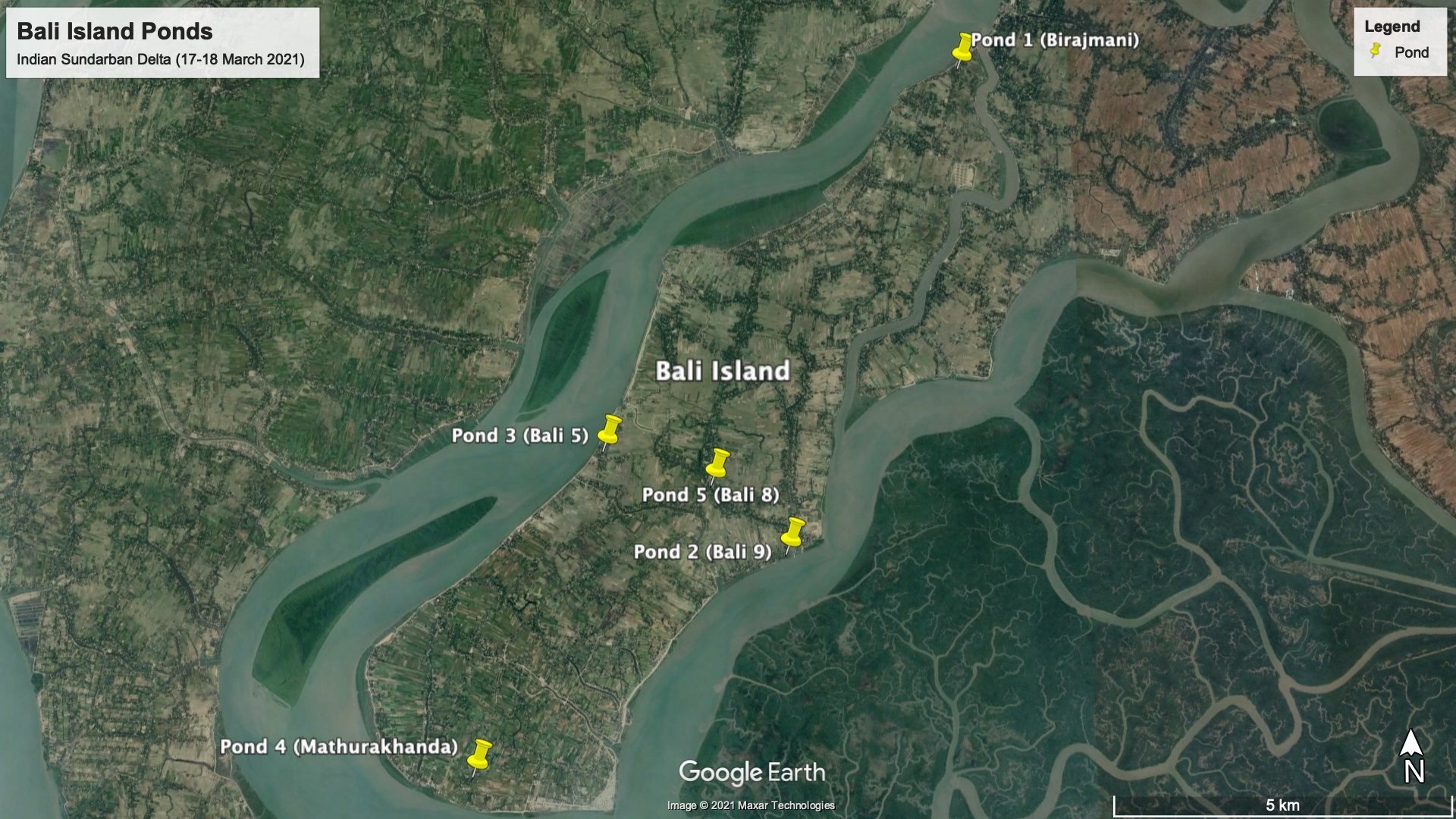
Map of ponds sampled as part of the Bali Island fieldwork, March 2021 (prepared by Sumana Banerjee).

Dr. Abhra Chanda collecting pond water in Bali Island, GBM-I.

Sourav Das conducting questionnaire with pond owners in Bali Island, GBM-I.

Sourav Das measuring pond physicochemical water quality in Bali Island, GBM-I.
Reference
1 “Bali, an island across tiger land”, Bangladesh Indian Sundarban Region Cooperation Initiative. Webpage URL.